Would you like to make this site your homepage? It's fast and easy...
Yes, Please make this my home page!
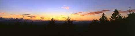
Wears Valley in the Smoky Mountains
 Home
Area Attractions
Gallery of Pictures
About Us
Contact Us
Weather Information
Smoky Mountain Information
Wears Valley Historical Information
Home
Area Attractions
Gallery of Pictures
About Us
Contact Us
Weather Information
Smoky Mountain Information
Wears Valley Historical Information
The Great Smoky Mountains National Park
Highlights of the National Park
Established: The Great Smoky Mountains National Park was created in 1934 to protect the last remnant of the southern Appalachian forest which was being exterminated by extensive logging.
Area: The park encompases 520,976 acres of land.
Elevations: The highest elevation is the summit of Clingman's Dome at 6,643 feet above sea level. The lowest point is the mouth of Abrams Creek at 840 feet above sea level.
Plant Species: There are over 1,600 species of flowering plants in the park. This includes 125 species of native trees.
Animal Species: There are 200 species of birds, 50 species of fish, and 60 species of mammals. The park is America's salamander capital with 30 species of these creatures.
Number of Visitors: The park receives almost 10 million visitors each year. It is the most visited national park in our country.
Park Activities: The park has an abundance of activities throughout the year including: hiking, bicycling, fishing, picnicking, campfire programs, horseback riding, cross-country skiing, ranger talks and walks, pioneer life exhibits and annual festivals. There is something for all interests and age groups.
Hiking: There are over 800 miles of trails to hike. Also, the Appalachian Trail cuts through the Great Smoky Mountains National Park on its way to its southern terminus in Georgia. There is approximately 70 miles of the AT through the park.
Camping: The park has 1,008 developed campsites and 100 primitive camp sites.
Horseback Riding: The park has an extensive system of trails for horses and is considered the best riding area in the eastern part of the United States.

Hiking Information
In the Great Smoky Mountain National Park, more than 800 miles of trails provide opportunities for hikers and strollers of all
ages and abilities. You can take an easy saunter for a short visit with nature, a week-long backpacking adventure in the forest or anything in between. For
those who prefer to commune with nature from the comfort of their vehicle, there are over 200 miles of paved and gravel back roads that provide an escape from the everyday annoyances of traffic and allow the visitor to enjoy some of the more remote and adventurous areas of the park.
Popular Hiking Trails in the GSMNP
| Trail |
Location
|
Round
Trip Mileage |
| Abrams Falls |
Western end of the Cades Cove Loop Road
|
5
Miles |
| Chasteen Creek
Falls |
Smokemont Campground
|
4
Miles |
| Grotto Falls |
Roaring Fork Loop Road
|
3
Miles |
| Hen Hollow Falls |
Cosby Campground
|
4.5
Miles |
| Indian Creek Falls |
Deep Creek Campground
|
2
Miles |
| Juneywhank Falls |
Deep Creek Road, 1/4 mile from campground
amphitheater
|
.6
Miles |
| Laurel Falls |
Little River Road
|
2
1/2 Miles |
| Rainbow Falls |
Cherokee Orchard Road
|
5.5
Miles |
| Ramsay Cascades |
Greenbrier Cove
|
8
Miles |
| Old Sugarlands |
Stone Bridge at Sugarlands Park
Headquarters
|
.5
Miles |
| Gregory Bald |
Cades Cove at the turnaround on
Forge Creek Road
|
11
Miles |
| Andrews Bald |
Clingman's Dome Parking Area
|
4
Miles |
| Mount Cammerer |
Low Gap Trail in Cosby Campground
|
12
Miles |
| Walker Sisters
Farmstead |
Greenbrier School off Lyon Springs Road
in Wears Valley
|
2
Miles |
| Charlie's Bunion |
Newfound Gap head east on the Appalachian
Trail (AT)
|
9
Miles |
Copyright 2002 As The Valley Turns All rights reserved.
Home |
Area Attractions |
Gallery of Pictures |
About Us |
Contact Us |
Smoky Mountain Information |
Weather Information|
Wears Valley Historical Information |